I wasn't sure I was looking forward to this after being out the whole day before but went along anyway and was so glad as I had a splendid day and saw a lovely lot of geology I'd not visited before.
We met up with our leader, Moira Jenkins from Worcester Earth Heritage Trust, at Swinyard car park at the southern end of the hills, near Gullet Quarry and, after a short introduction, headed off to the quarry.
This quarry is in the igneous intrusive Malvern Complex which is Precambrian in age (<680 div="" ma="">
After the initial intrusion there were two periods of granite intrusion, metamorphism, shearing, alteration by hot fluids and intrusion by microdiorite dykes and pegmatite sheets.
.
 |
| View of the north face of Gullet quarry from the path along the southern side. |
The quarry face of interest is currently inaccessible after some unfortunate drownings there in recent years but Moira told us that there are negotiations with the Malvern Hills Conservators to install a locked gate so that
bona fide groups can get to the interesting exposures above the ramp on the north side. She pointed out pegmatite and shear zones but the light was not as good as it might have been for viewing these.
 |
| The ramp, currently out of bounds, gives access to pegmatite veins and shear zones on the north side |
 |
| I was intrigued by what appeared to be a darker band running across the quarry face - maybe a one of the more mafic dykes? |
Exposure on hill to south
We followed a path uphill, south of the quarry, crossing over beds of Cambrian basal quartzite.
 |
| Exposure in the track with patches of quartz pebbles |
 |
| Area of quartz pebbles |
This is part of the Cambrian Malvern Quartzite exposed in a thin sliver between two outcrops of the Malverns Complex igneous rocks. Moira has explored here for a possible Precambrian/Cambrian unconformity,
After a look at this we scrambled up the bank on the left to our goal: a small digging, which had probably provided stone for the track.
 |
| Moira explains our task here! |
This sloping surface is probably (burrow evidence) a bedding plane of sandstone with conglomerate patches. However, at one end there are what appear to be beds of conglomerate, green and orange sediment, and bedding planes perpendicular to the surface so perhaps there is some faulting or folding going on, though we couldn't see any evidence. The interpretation of the sediments and fossils here is of a Cambrian shoreline where the sea adjoined a rocky island.
 |
| A patch of conglomerate on the sloping (bedding plane?) surface in the digging by the trackside. |
Top of Gullet Quarry
We retraced our steps and climbed up to the bench at the top of Gullet quarry, on the west side, getting another view of the inaccessible north face on the way.
 |
| View of Gullet Quarry as we climbed up to the top bench |
The top bench is where Llandovery (Silurian) rocks are in contact with the igneous Malverns Complex. It reminded me of the exposures at the Ercall in Shropshire but, although the depositional settings are similar the two were probably on different terranes at the time!
 |
| Silurian (Landovery) sediments on the left, striking more or less N-S and dipping steeply to the west. Malverns Complex igneous rocks on the right. Around the junction (not seen here) there are patches of conglomerate. |
The environmental interpretation is of sediments deposited against, and close to, a rocky shoreline.
 |
| The Silurian sediments above Gullet Quarry. There are ripple marks on the left side (top) of the thick sandstone bed bove the tree on the right. |
 |
| Closer view of the ripple marks - shallow sea |
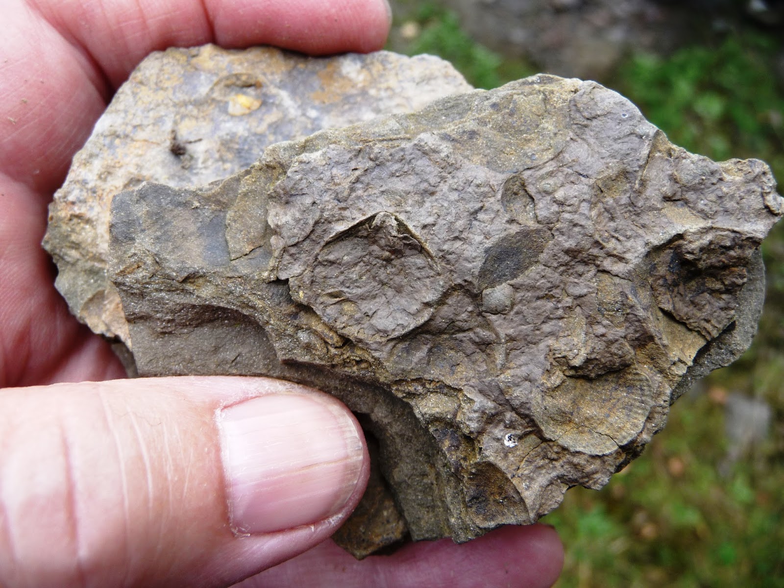
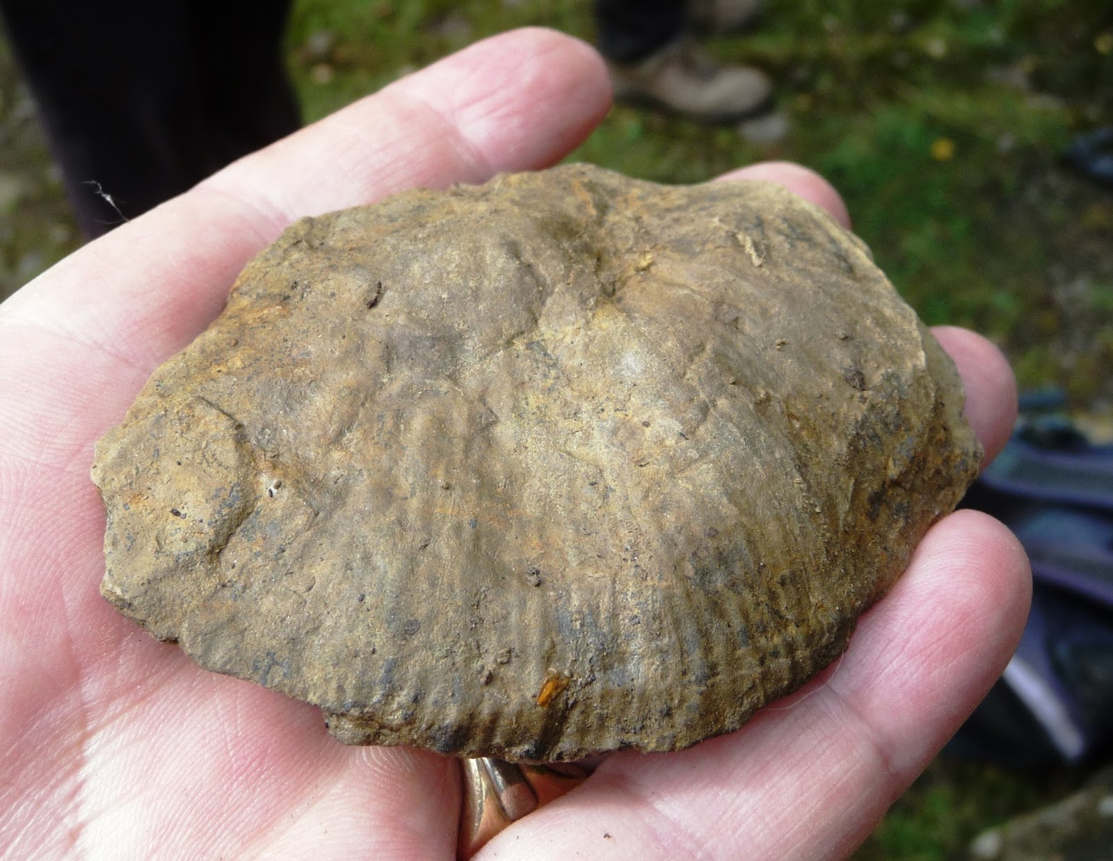
As well as investigating the junction between the different rocks, Moira set us to looking for fossils and we quickly accumulated quite a collection.
 |
| Investigating the variety of fossils we found - bivalves, brachiopods, solitary coral, burrows and an orthocone |
 |
| Brachiopods in a lag deposit |
 |
| Ichnofossils - burrows |
 |
| Brachiopod valves on a bedding plane |
 |
| A solitary coral - sorry it is a bit fuzzy! |
 |
| And this big beastie! The best match I can come up with is Costistricklandia lirata (going by the illustration in British Palaeozoic fossils of a similar one from Llandovery rocks near Ledbury. |
Heading up through the woods we eventually popped out on the top of the ridge where we had splendid views!
The views from the top
From here we could see the seep gash of the east-west valley of the Gullet stream. This stream, unusually in the Malverns, starts on the west side and flows east, probably exploiting a line of weakness along a fault. During the most recent glacial permafrost meant that the lower ground (Mercia Mudstone Group sediments with ridges of Arden Sandstone) of the Severn Valley, east of the Malverns, was frozen. This allowed the stream and its sediments to spread out in an apron over frozen ground of what is now the hummocky, gently sloping land of the Common, and the stream(s) flowed on down to the Severn. Now as the Severn has cut down its bed, nick points are working their way back up from the point where the streams join the river.
 |
| View from the top, above the cleft of the Gullet Stream |
The East Malvern Fault line, on the eastern side of the ridge, is a major and long lived fault with periods of activity at 540 Ma and 440 Ma. This area was one of island arcs, above sea level. On the far side of the Severn Valley is the Inkberrow Fault, and the Mesozoic escarpment so that the river flows in the intervening graben.
 |
| Looking east over the hummocky apron of gravels, to the Severn valley and beyond to the Mesozoic escarpment east of the Inkberrow fault |
A little further on we got a good view west, all the way to the Black Mountains, and Sugar Loaf above Abergavenny. Completely different from the geology to the east, on this side there is a mixture of Silurian limestone ridges and clay vales before reaching the Old Red Sandstone outcrops.
 |
| View west over the Silurian limestone ridges and clay valleys of the Ledbury anticlinorium |
 |
| Look hard and you may be able to see Sugar Loaf over to the left, and Hay Bluff (at the northern end of the Black Mountains) on the right! |
We carried on up the ridge and then, dropping down to the west, we continued along it to Clutter's Cave.
 |
| Looking north up the ridge |
Clutter's Cave
This is a man made cave (currently provided with rather dirty looking bedding!) which has been excavated in a pile of pillow lava and dykes, part of the spilitic lavas of the Warren House Formation which outcrops in a fault-bounded area here and on the slopes to the east.
 |
| Clutter's Cave, Moira Jenkins (leader) and Jan Ashton-Jones (organiser) for scale |
There was quite a bit of debate about what were, and weren't, pillows and/or dykes, and we also investigated supposed carbonate veins in path exposures just north. The white vein material is soft (I scratched it very easily with my trusty Girl Guide knife!) but we couldn't get it to fizz. Perhaps it has been dolomitised by circulating seawater? Any thoughts anyone?
Below British Camp
 |
| The southern, less defended, part of British Camp |
We paused by the rugged, stone built (and probably almost indestructible) planation table, one of several we had seen along the ridge, to look at the view north.
From here it was easy to pick out the line of the northern section of the Malvern Hills, beyond the A449 and the Malvern Hills Hotel. It is very obviously dextrally offset from the trend of the southern ridge on which we were standing.
 |
| British Camp on the left, and the line of the northern Malverns on the right, offset to the right north of the A449 |
 |
| The planation table, and the view of the northern hills |
 |
| In the centre of the table there was a splendid chunk of mafic rock with coarser-grained, gabbroic areas, cut by a vein of reddened granite. |
Warren House Formation
We followed a path to the north east, down from the col, past Pink Cottage (yes, it is pink, at least partially), to an exposure of the Warren House Fm
 |
| Investigating the Warren House Fm on the east side of the Malverns below Pink Cottage |
This is described as tuff but to me it looked more like an autobrecciated mafic lava - a hyalosclastite. I couldn't convince myself that this was even a welded tuff but would be very happy to be put right! We found some vesicles, and some of them were filled with epidote.
 |
| Tuff? |
This was the final "proper" stop and we went down a steep and rather "ball-bearingy" path to the bottom of the ridge where we joined up with the track heading back south to the car park. This crosses the apron of Malvern Gravels which was deposited on the frozen soil at the end of the last glaciation and Moira explained how the gravels can be used to trace back to the source rocks uphill.
 |
| Checking out stream gravels |
From here it was a short walk back to the cars but, sadly, and unusually, no ice cream van!


No comments:
Post a Comment