The Caminito del Rey
The walkway was constructed at the start of the 20th century to provide access for the hydro electric power plant workers. When King Alfonso XIII used the walkway in 1921 to inaugurate the Conde del Guadalhorce dam the route got its present name. It rises over 100 metres (330 ft) above the river below. (Wikipedia) The original walkway was built of steel girders projecting from the rock face and supporting concrete slabs. It fell into disrepair and towards the end of the 20th century it was generally only used by climbers and thrill-seekers. Sadly in 1990 and 1991 two people lost their lives, and the walkway was closed; four more were killed between 2009-2013.
Some geological background
Between the three reservoirs north of Ardales and El Chorro the Guadalhorce river has cut deep, narrow, limestone gorges through Mesozoic sedimentary rocks. The rocks are part of the Internal Subbetic Zone of the Betic Cordillera, they have been folded by the Alpine Orogeny and strike roughly east-west. This means that the north-south gorges, running perpendicular to the strike, expose a sequence of strata. Later Miocene sediments have been deposited unconformably on the folded rocks.
The route divides, geologically, into five stretches:
- The walk from the road to the north access: this is mostly over Miocene (Tortonian) sandstone resting unconformably on the Mesozoic rocks
- The first gorge section through Jurassic limestone (blue here)
- The central section where younger red beds have weathered to a gentler profile
- The second gorge section, again mainly through Jurassic rocks but with older Trias showing through underneath.
- The walk out to the shuttle bus which is across Tortonian sandstones and conglomerates resting unconformably against vertical Jurassic limestone.
 |
The geology of the area around the Caminito del Rey
(based on IGME Sheet 1038 Ardales)
with the approximate route of the Caminito del Rey
shown in red. |
We set off from Loja in good time to reach the northern access near the northern end of the Conde del Guadalhorce reservoir and walk to the entrance point for the caminito. Already busy by 9.30 am, we found a parking spot a couple of hundred yards from the Restaurante El Kiosco, popped our boots on, picked up our bags and set off.
Walking to the north access point
I began photographing the geology at the entrance to the tunnel by El Kiosco! (You can see the others are 100 m ahead already!) The rocks here are Upper Miocene (Tortonian) sandstone. They are well cemented (the tunnel has no visible means of support so I suppose they must be!) are coarse grained, and show some cross-stratification. At this time a series of basins stretched from the Atlantic, via the Guadalquivir Trough, to the Mediterranean linked basins of Malaga, Granada and Almeria. Emergent areas, such as those formed by the Jurassic limestone here, were surrounded by marine basins where sandstones and conglomerates were deposited.
 |
| The entrance to the access tunnel by Restaurante El Kiosco |
 |
| Cross stratified sandstone of Miocene age. The cross set is about 25 cm high. |
From here the path contours along the hillside, above the Embalse de Gaitanejo, passing through pine and palmetto woodland. It was beautifully cool on this north facing hillside at this time on an autumn morning!
 |
| Beds of Miocene sandstone and conglomerate alongside the track. |
 |
| Jayne and Jan for scale in this one! The well cemented siliciclastic rocks form stable, vertical cliffs |
About half-way along the access path we must have crossed the unconformity onto the older, underlying limestone deposited during the Late Jurassic and the very earliest Cretaceous (Berriasian) but this is less well exposed along the track which continues along above the Embalse. Next time there will be an unconformity search going on!
 |
| The access track runs along above the Embalse de Gaitanejo: the change to limestone is clear as higher relief |
We arrived at the North Access point in good time to use the loo etc and queue up for our turn: judging by the number of people this walk is very popular, even on a October weekday!
 |
| The 1015 people are queued up on the left, a little while later we, along with the other 1030 people, were invited to begin a queue on the right. There's a ticket booth here: generally it is better to book ahead on their website but there is a small percentage of tickets reserved for sale on the day. |
Once through the turnstile we held back to let the others in our cohort forge ahead - a lot of people seem to regard this as a "yomp" - how fast can you get from one end to the other?! - whereas we were keen to have uninterrupted looks at rocks and birds without people pushing past all the time!
The first gorge section
The first section of gorge (Tajo de Almorchon) is cut through limestone of Late Jurassic carbonate rocks. The 110 - 130 m thickness of oolitic limestones, grey limestones and a few nodular and brecciated limestones span the top of the Jurassic (Kimmeridgian) into the bottom of the Early Cretaceous (Berriasian). These massively bedded rocks are harder than the Miocene sandstones across which we've been walking and consequently produce higher relief though they are intercalated with some 5 - 10 m thick beds of softer rock in which (apparently) ammonites are to be found. The rock is a biomicsparite with gravel, intraclasts, pellets and foraminifera (if I'd read this information before going, I'd have looked harder for these features!)
 |
| Looking ahead through the Desfiladero de Gaitanejo at the eastern end of the Gaitanejo reservoir. The hydroelectric power station in the bottom of the gorge. A problem with doing the walk in the morning is that you've got the sun in your eyes! |
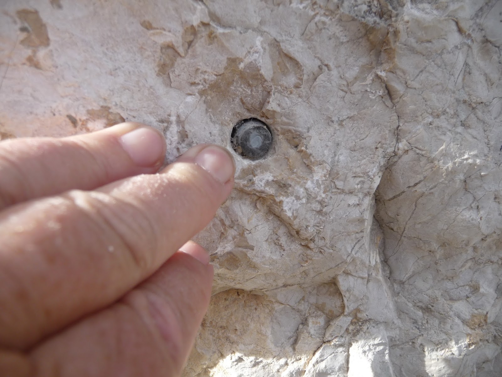
We thought at one point we had found a belemnite but, on finding more and more of these, and then inspecting more closely, we realised that the were the ends of bolts in the rock that had been cut off flush! Oops! Presumably a relic of the construction phase.
 |
| Not an end-on belemnite! |
 |
Jurassic limestone crags on the skyline and the slope below with younger, softer, Cretaceous marls and marly limestones (Albian-Cenomanian) in front of them,
We are standing at the start of the first gorge section looking back to the far side of the reservoir, |
 |
| Plaques commemorating the original walkway and the refurbished, present one |
 |
| The path through the first gorge |
 |
| A set of thinner beds, dipping north, on the far side of the gorge |
 |
| There appears to be dissolution along the bedding planes in the limestone |
 |
| Approaching the central section, Jayne for scale! |
 |
| Limestone weathered into rills (Jan's hand for scale) |
 |
| Looking south - the path winds down into the more open centre section |
 |
| Folds! |
 |
| I wonder if this is what the IGME Sheet Memoir means by "gravelly" micrites? The clasts are limestone, maybe pebbles off a beach reworked and redeposited with micrite in shallow water? |
The central section
At the southern end of the first gorge section there is said to be a faulted contact with younger and less resistant capas rojas - red beds - of Late Cretaceous (Turonian to Maastrichtian) age. These are much more vegetated than the limestone and the gentler hillsides afford much less exposure but, according to the geological map, they dip SW at about 45 degrees.
 |
| Although the river still flows through a gorge the central section is much more open |
 |
| Looking back at the northern gorge section, with the railway embankment and tunnel on the right |
 |
| More limestone eroded into rills |
 |
| Gentler slopes in the central section underlain by Cretaceous marls and red beds |
 |
| Jurassic limestone in the distance and the foreground with middle to Late Cretaceous marls and red beds in the gap between the two. |
 |
| North dipping beds of Jurassic limestone with younger, more flat-lying Cretaceous marls and red beds in between |
The second gorge section
This is particularly spectacular but also quite a muddle geologically because of folding and a number of faults which chop up the rocks. With the benefit of hindsight we would have looked more carefully at the nature of the rocks we were passing, and tried to spot the different lithologies and the junctions between them.
From north to south there are apparently (1) Jurassic (Kimmeridgian-Berriasian) age limestones which we saw before in the northern gorge, then (2) thick beds of Triassic marl, dolomite and gypsum in the core of an anticline before reaching the south dipping Jurassic rocks again, first (3) the Oxfordian-Kimmeridgian Ammonitico Rosso and then (4) the younger Kimmeridgian-Berrasian unit again.
The 30 - 50 m thick Ammonitico Rosso is well known as a good marker horizon in the Internal Subbetics. It gradually oversteps the underlying beds and is made up of nodular limestones, and red/yellow breccias. The beds are described as thin (25-60 cm) and interleaved with less competent layers. They are biopelmicrites and rich in fauna.
 |
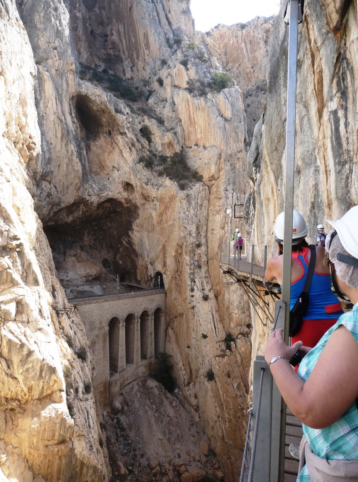
| The start of the southern gorge section through the Desfiladero de los Gaitanes |
 |
| Looking back from the start of the 2nd gorge across the central section to the first gorge. Such a difference in relief! The folded Jurassic limestones are very prominent, whilst the Cretacous marls and red beds erode more easily |
 |
| The railway line pops out in the most unexpected places looking more like the fantasies of a train set enthusiast than a real, life-size railway line! Bedding in this southern gorge section is well nigh vertical - a gift to a graphic logger! |
 |
| The end of the Desfiladero de los Gaitanes with the Embalse Taco de la Encantada coming into sight |
 |
| Vertically bedded limestone on the east side of the southern gorge. Hard to judge bed widths but the railway line is just visible bottom left |
 |
| Getting closer. Part of the old walkway visible bottom right, and the old bridge across the gorge, in front of the new suspension bridge |
 |
| THE ammonite! Yes, just the one, and conveniently at eye level but protected with a thick transparent sheet. Hard to put a name to it, given the state of the mould. I can't find anything of the right age in my British Mesozoic Fossils. |
 |
Opposite the section of vertical beds the gorge has been eroded back along the bedding and the walkway
follows it round in a "hairpin". The old walkway is just below the new one at this point. |
|
 |
Opposite the section of vertical beds the gorge has been eroded back along the bedding and the walkway
follows it round in a "hairpin". The old walkway is just below the new one at this point. |
 |
| Vertical beds which are brecciated, or dissolved or somehow broken up along the bedding planes. |
 |
| The old bridge, new one behind |
 |
The vertical limestone face above the embalse Taco de la Encantada. The green box girder bridge is for the railway.
Miocene basin sediments are banked up against this face, it was likely to have been a cliff at the edge of one of the chain of basins linking the Atlantic to the Mediterranean |
 |
| A less complicated description of the geology! |
The final section
After the climb up the steps over the railway, where the walkway clings to the sheer limestone face, it was quite a contrast to find ourselves on a gravel track, heading for El Chorro and the shuttle bus. This is a surprisingly long stretch, but not completely unfamiliar as we had explored it, and a lower track, back in 2003 so I'm finishing up with some photos I took then of the Miocene conglomerate here. This is part of the same unit we began on, but striking here as it buts up unconformably against the cliff face.
 |
| The track towards the caminito in 2003. |
 |
| From the Bobastro area, the areas of Jurassic limestone and the areas of later sediment can easily be distinguished |
 |
| From the far side of the embalse the junction between the much flatter lying Miocene sandstones and conglomerates and the vertical Jurassic limestone is very clear |
 |
| Back on the track above the railway again, the Miocene conglomerates and sandstones |
 |
| In close up the relationships are complicated! |
 |
| Conglomerate or breccia? Whichever you go for it is clast supported and contains a lot of limestone fragments |
The final stretch back to the station in El Chorro, where the shuttle bus picks up to ferry back to the start, was hot! It was early afternoon by now with the temperature in the low 30s and we were very glad to find kiosks selling ice creams and cold drinks! There's also a cafe at the station.
Cautionary note
This write up is very much a work in progress. The first walk along the Caminito was in the nature of a reccy. Having followed this up with a look at the local geology map, and the Sheet Memoir, I'm very much looking forward to going back next time I'm in Andalucia so that I can look at parts of this in more detail - I'll be drawing up a list of questions to answer!
In the meantime I'd welcome any input, particularly from anyone who knows the area's geology better than I do.
Bibliography
- Gibbons W and Moreno T (eds) The Geology of Spain. The Geological Society (2002).
- British Mesozoic Fossils. The Natural History Museum, 6th edition (1983).
- Mapa Geologico de Espana, escala 1:50 000; Segunda serie, primera edicion. Sheet 1038 Ardales. Instituto Technologico GeoMinero de Espana (IGME) (1990)


No comments:
Post a Comment